Our History
Ngāti Koata Te Iwi
What makes us Ngāti Koata ultimately is our ability to whakapapa to our ancestress Koata of Tainui. The rich heritage and history that Ngāti Koata has is embodied in its people, its places and its taonga.
Ko Wai? Nō Whea? | The Historic Journey of Ngāti Koata
For Ngāti Koata the journey begins with the early navigator Kupe, who arrived to Aotearoa from Hawaīki c.925. Although the human face of Koata had not yet been revealed, the names, traditions and stories associated with his arrival are integral landmarks within the rohe(boundary) of The Ngāti Koata Trust.
“Whatungarongaro te tangata, toitu te whenua. ” – People pass on but the land remains
Ko Tainui te waka, Ko Hoturoa te tangata.
Ngāti Koata originates from the waka of Tainui that left Hawaīki and arrived in Aotearoa c.1400. Tainui was captained by Hoturoa and was finally hauled ashore to rest between the two pillar stones of Puna and Hani in Kāwhia (located behind the Maketu Marae).
Ko Ngāti Koata te Iwi.
Ngāti Koata takes it name from the ancestress Koata who was born c.1617. She lived in the Kāwhia area where she had two sons, Kāwharu and Te Wehi (the latter becoming Ngāti Te Wehi).
It is through the union of Kāwharu of Koata, and Waikauri of Toa that the interwoven whakapapa lines between the two iwi begin.
Although not much has been written about her there are many oral stories that have been passed down through the generations. Tradition states that upon her passing, she was taken by her hāwini (maids in waiting) and buried in an unknown location.
Kāwhia Kai, Kāwhia Moana, Kāwhia Tangata
Peace initially dwelled amongst the people of Koata as they settled the land. Conflict began to arise around population growth, intermarriages and land boundaries leading to an exodus of people from Kāwhia in the early nineteenth century. Ngāti Koata who formed an alliance with their whanaunga(relations) Ngāti Toa and Ngāti Rārua also departed. Many Koata remained in the Kāwhia area and to this day we try to maintain strong relationships with them.
The main heke (migration) for Ngāti Koata was called ‘Te heke Whirinui’ led by our Tupuna, who were known for their military strength. They travelled down the Western side North Island and with the support of Ngāti Awa, Koata travelled through Taranaki and continued onto Te Waewae Kapiti o Tara rāua ko Rangitāne (Kapiti Island) where they had settled at Te Waiorua. Soon after, Kurahaupō tribes led an assault on the Tainui tribes on Kapiti.
An important leader of the Kurahaupo waka, Tutepourangi was captured. A Ngāti Koata child, Tawhi, was also captured and taken South. With Tutepourangi onboard, Ngāti Koata followed the retreating waka to retrieve Tawhi. Realising the severity of the situation Tutepourangi gave a tuku (ceeding) to Ngāti Koata in exchange for the safety of his people and the safe return of Tawhi. This tuku was accepted by Te Putu.
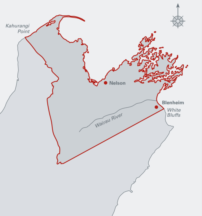
The boundary of this tuku extends from the Clay point to The Trios, to The Jags, to Takapourewa and to Farewell Spit.
Mai Anatoto ki Kurupongi, ki Nga Kiore, ki Takapourewa whiti atu ki Te Hiku o Te Matau.
Ko Maungatapu te maunga, Ko Maitahi te Awa, Ko Te Aorere te tai
Ngāti Koata were the first of the five Northern Iwi to establish themselves as manawhenua and many intermarriages between the people of Ngāti Koata and the original iwi of Kurahaupō occurred.
Due to colonisation many of our people became alienated from their coastal lands. Whakatū (Nelson) and its adjoining areas became one of the major destinations for education and employment. Maungatapu the mountain, Maitahi the River and Te Aorere the sea coast are associated with this area and form part of our rich tapestry.
Ngāti Koata continue the migration tradition today and currently live all over the world, although Te Tau Ihu continues to be our home.
He Kōrero Ō Nehe | Historical Timeline
1825
1839
1840
1844
1845
1848
1852
1883
1894
1937
2006
2007
2009
2011
2012
Our Rohe
Territorial boundaries are referred to as ‘rohe’ in te reo Māori, and are generally defined by prominent geographical features, such as maunga (mountains), awa (rivers), moana (seas), and roto (lakes).
The rohe of Ngāti Koata includes the whenua (land) and moana (sea) contained within the tuku of Tūtepourangi. From Anatoto at the mouth of the Pelorus Estuary and including the Sounds and around the coast from Kaiaua (Croisilles Harbour) to Cape Soucis, Whangamoa, Whakapuaka, Whakatū, Waimea, Motueka, and on to Te Matau (Separation Point). Ngāti Kōata oral tradition says that the tuku started at Anatoto at the mouth of the Pelorus Sound and included Kurupongi, Nga Kiore, Takapourewa and extended to Onetahua (Farewell Spit). Subsequent occupations also included the Pelorus Sounds.
Pepeha
The rohe of Ngāti Koata is encapsulated in the following pepeha.
Mai te awa Te Hoiere
Ki Kurupongi
Ki Ngā Kiore
Ki Takapourewa
Whiti atu ki te hiku o Te Mātau
Koata taonga
Koatatanga
Koata mana e!


Deed of Settlement
The Ngāti Koata Deed of Settlement is the full and final settlement of all historical Treaty of Waitangi claims of Ngāti Koata resulting from acts or omissions by the Crown prior to 21 September 1992.


Ko Wai Toku Iwi?
Our Values Include: